Op-ed · June 2026
I can't legally ride my bike to Lidl, and the fix is one sentence
Lidl is less than half a mile from my house, but I can’t legally ride my bike there. There’s an easy fix, and it brings us in line with our neighbors.
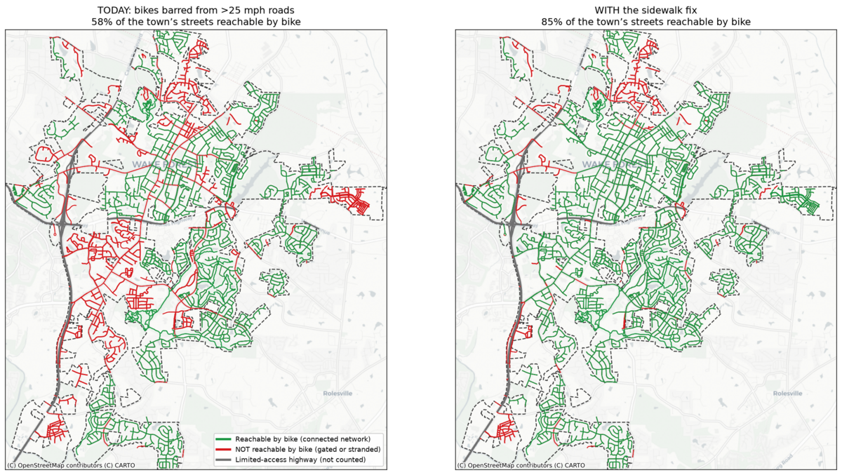
The Town of Wake Forest recently took a real step forward for bikes and other micromobility. The Board of Commissioners recently amended our ordinances to do two things. It expanded where e-bikes, e-scooters, and similar devices may legally go, including shared streets, greenways, parks, multi-use paths, and bike lanes. It also gave the Town better tools to deal with the illegal mopeds and motorcycles styled as bikes that have been causing problems for residents. That is real progress. However, the rules as written leave only about 58 percent of the town’s streets reachable by bike. One more change would push that to about 85 percent.
Two reasonable rules that collide
Two rules, each sensible on its own, add up to a wall.
The first is that you can’t ride a bike on a sidewalk in Wake Forest. Downtown, that rule makes sense. It keeps people walking on Main Street safe from bikes weaving past them.
The second is that you can’t ride a bike or scooter on any road posted over 25 mph. That rule is about safety too, and the numbers behind it are grim. A person struck at 20 mph survives about 90 percent of the time. By 30 mph the odds fall below half, and by 40 mph to roughly one in three. A cyclist’s chance of being killed doubles at 30 mph. The big multi-lane roads are the single most common place cyclists die, about 37 percent of fatal bike crashes, usually when a faster vehicle overtakes the rider. Keeping bikes out of 35 and 45 mph travel lanes is the right call.
Put the two rules together, though, and you get a trap. On a fast road with no bike lane, a rider has no option that is both legal and safe. They can’t ride the road, and they can’t ride the sidewalk. The choice becomes break the law in traffic or stay home. These fast roads turn into walls that cut neighborhoods off from the stores, schools, and greenways on the other side.
A half-mile errand, the long way around
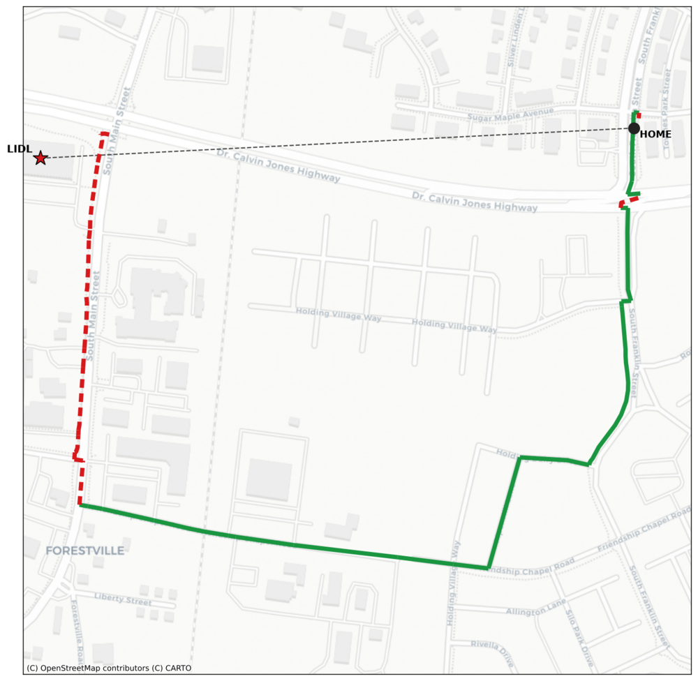
Here is what that looks like from my driveway. Lidl sits 0.46 miles away in a straight line, a three-minute ride. To get there legally on a bike today, I have to thread between Dr. Calvin Jones Highway (NC-98) and South Main Street. Both are posted at 35 mph, and neither has a bike lane.
I mapped the shortest route I can legally ride, and there isn’t a short one. The direct links from my neighborhood to South Main are either gated 35 mph roads or a private drive posted “no thru traffic,” so the shortest legal public route runs about 1.1 miles, nearly two and a half times the straight-line distance. And the last third of a mile, I still have to get off and walk my bike down the South Main sidewalk, which I’m not allowed to ride.
Lidl even put a bike rack out front. There is no legal way to ride to it.
The same wall, all over town
This pattern repeats everywhere. By my count, about 97 of the town’s 328 miles of neighborhood streets, close to one in three, are cut off from the connected network, stranded behind a fast road with no legal way across on two wheels.
It produces some odd results. Take the greenway access off Rogers Road, a good connection to the trail network that is now close to useless, because you can’t legally ride the roads or the sidewalks around it, and it sits too far from anything to reach on foot. We built the trail and then wrote a rule that puts it out of reach.
The map below shows the whole town, today on the left and after the one-sentence fix on the right. Every red street is one you cannot legally reach by bike, a road posted over 25 mph or a neighborhood stranded behind one. (The gray lines are the limited-access highways, US-1 and NC-98, which are not streets and are not counted.) Today only about 58 percent of the town’s streets are reachable; with the fix, almost all of that red turns green and 85 percent become reachable. You can explore the interactive map and zoom to your own street.
Why the fix makes everyone safer
Letting bikes use the sidewalks along those fast roads does not trade away safety. It adds it.
The Federal Highway Administration recommends a separated path or sidewalk-style facility for bikes on roads over 30 mph, precisely because riding in the travel lane there is so dangerous. Towns with separated bike facilities see about 44 percent fewer traffic deaths for everyone on the road, not just cyclists. Moving a rider out of a 45 mph travel lane and onto the sidewalk next to it is the separation the safety research asks for.
It protects people on foot, too. The sidewalks along our high-speed roads carry very few pedestrians. They run past parking lots and highway shoulders, not the cafes of downtown. Allowing bikes there, at low speed, with a clear duty to yield, is nothing like allowing them on a crowded Main Street sidewalk. The downtown ban can stay exactly as it is.
To make the pedestrian priority plain, the Town should post “Bikes Yield to Pedestrians” signs (the standard MUTCD R9-6) along these corridors, even under a blanket rule rather than only on a signed subset. Pedestrians always have the right of way. The signs just say so out loud. One detail is worth getting right. Where a sidewalk runs on both sides of a road, open both, so riders can travel with traffic on the near-side sidewalk instead of against it. Riding against traffic at driveways and intersections is the most crash-prone way to use a sidewalk.
Other North Carolina towns already do this
We would not be inventing anything. Letting bikes and similar devices use sidewalks, with a duty to yield to pedestrians, is the norm in the towns around us, and several have already written close to the exact rule Wake Forest needs.
Holly Springs is the closest parallel. This year, facing the same complaints about fast and reckless e-bike riding that prompted Wake Forest to act, its Town Council passed a micromobility ordinance that took effect June 1, 2026. Rather than ban the sidewalks, Holly Springs kept e-bikes and other low-speed electric devices on sidewalks, side-paths, and greenways, with three conditions: yield to pedestrians at all times, keep speeds down (under 15 mph on greenways and side-paths), and signal before passing. Machines powerful enough to count as mopeds or motorcycles are barred from those spaces, and repeat violators face escalating fines and impoundment. Same problem, same season, opposite choice on the sidewalk.
Apex writes the model into its code. Under Sec. 20-143, a person may ride a bicycle, scooter, or skateboard on any public sidewalk, with due caution, yielding to all pedestrians, at no more than ten miles per hour on narrow sidewalks and at crossings. The only exception is a few named blocks in the walkable heart of downtown. Bikes and scooters on the sidewalk everywhere, except where foot traffic is heaviest: that is the balance Wake Forest should strike.
Cary keeps it simplest (Sec. 34-250): ride a bicycle on any sidewalk in town, with due caution, yielding to pedestrians. Raleigh allows bicyclists on sidewalks, greenways, and multi-use paths citywide, requiring them to yield and to stop before crossing a street (Sec. 11-3004 and 11-3005), though it keeps stand-up motorized scooters off the sidewalk. Chapel Hill allows sidewalk riding at a walking pace.
The common thread is what Wake Forest needs: bikes and micromobility off the sidewalk where people are walking in numbers, on the sidewalk where the only other choice is a high-speed road, always at low speed and always yielding to pedestrians.
Two ways to do it
There are two ways to do this.
The simple version, and the one I would pick: “Bicycles and micromobility devices may use the sidewalk along any street posted over 25 mph where no bike lane is provided, yielding to pedestrians at all times.” One sentence. It connects the whole town, and leaves the downtown sidewalk ban alone.
The targeted version posts signs on a specific list of sidewalks where bikes may share the walk, with the yield reminders that are standard in towns that do this. My mapping shows that a carefully chosen 8.8 miles of sidewalk, roughly 100 signposts, would reconnect the town with sensible routes. As little as 4.9 miles reconnects every stranded pocket, if barely. This works, but any limited list leaves some homes and businesses out by definition. The blanket rule does not.
Cheaper to run, better for your health
Connecting the network pays off beyond convenience. A typical car gets around 25 MPG, which at the roughly $3.50 a gallon in Jun 2026 ends up costing us about 14 cents a mile. An e-bike costs about 1/4 of a cent a mile of electricity, roughly 50 times cheaper to run. And even an electric car, a great improvement over a gas vehicle, still costs about 15 times more per mile than the e-bike: it uses about 15 times the energy, hauling two tons of metal to carry one person. Ten miles of errands costs about $1.40 in a gas car, about 40 cents in an electric one, or about three cents on the e-bike. The electricity to match a single tank of gas would carry an e-bike around 13,000 miles. This adds up even for small trips: My round trip to Lidl half a mile away costs a fraction of a cent to bike and 25 cents or more to drive.
It is also good for us. Even with the motor helping, e-biking counts as moderate to vigorous exercise. Studies find real gains in fitness, including 8 to 10 percent improvements in peak oxygen uptake among less-fit riders, along with lower blood pressure, and it opens cycling to older and less-fit people who could not manage a regular bike up our hills. A town where a half-mile grocery run is a pleasant ride instead of a car trip is a healthier and cheaper place to live.
The ask
Wake Forest already did the hard part. This is the easy part. Add one sentence letting bikes use the sidewalk on roads over 25 mph that have no bike lane, with pedestrians always given the right of way. It keeps fast roads safe, keeps downtown sidewalks for walkers, and finally lets me, and about a third of the town, ride a bike to a store half a mile away.
The interactive map is at highprofilesite.com/wfmicromobility. The open data, code, and full methodology behind this analysis are at github.com/spinkham/wake_forest_micromobility.